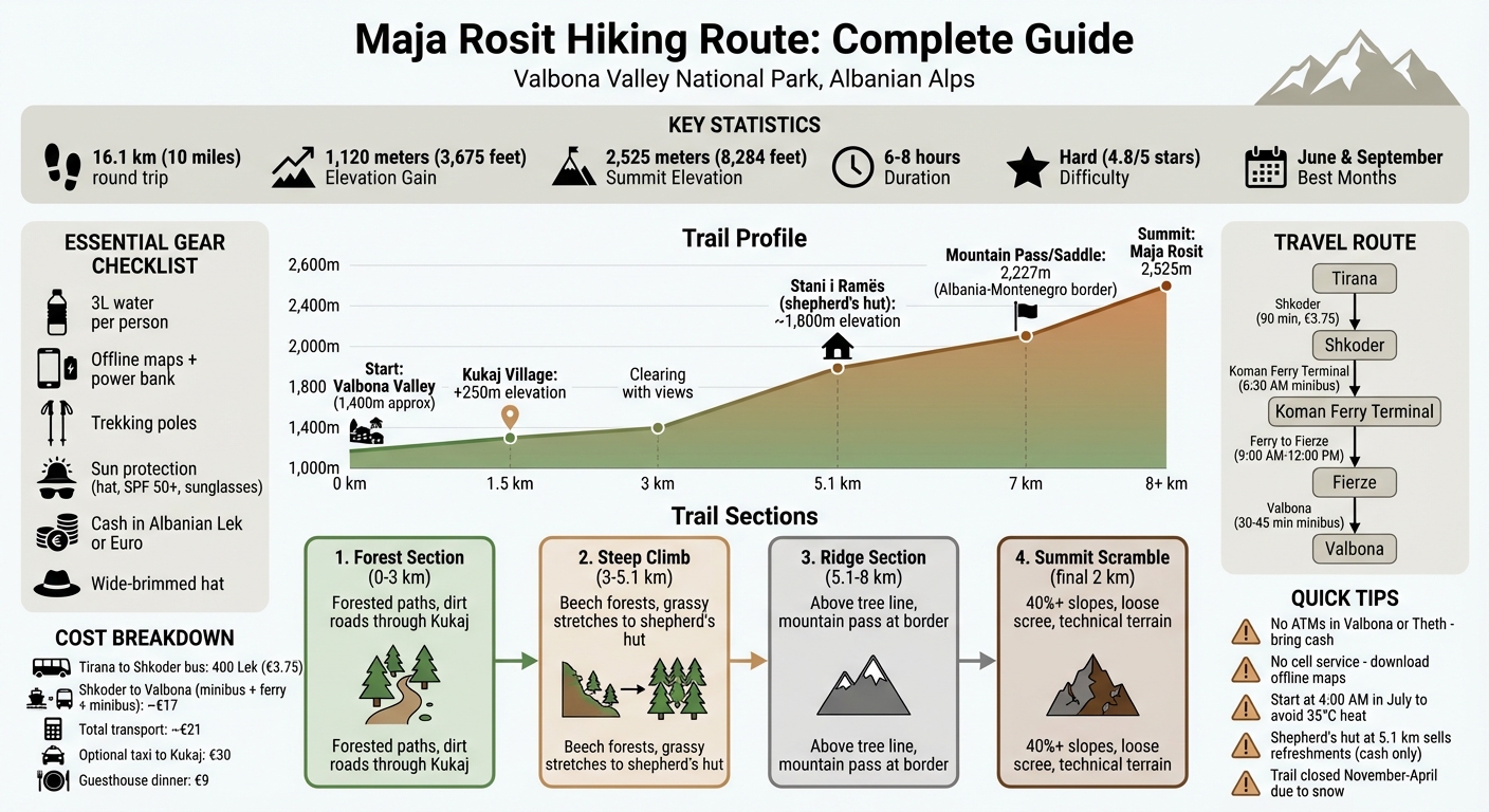
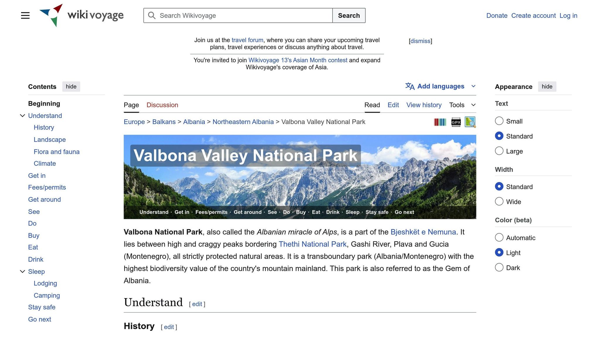
Looking for a challenging hike in the Albanian Alps? The Maja Rosit trail, starting in Valbona Valley National Park, is a must-try for seasoned hikers. This 16.1 km (10 miles) route climbs 1,120 meters (3,675 feet) to a 2,525-meter (8,284-foot) summit, offering stunning views of Albania and Montenegro. The hike takes 6–8 hours and passes through Kukaj village, alpine meadows, and a steep ridge before reaching the summit.
Key Details:
- Starting Point: Valbona Valley National Park
- Difficulty: Hard – steep climbs, exposed terrain
- Best Time to Hike: June or September for ideal weather
- Costs: ~€21 for transport from Tirana/Shkoder to Valbona
- Essentials: Offline maps, 3L water, trekking poles, cash in Lek
Prepare for a tough yet rewarding experience with breathtaking views of rugged limestone peaks, wildflower meadows, and the serene Valbona Valley. If you’re up for the challenge, Maja Rosit won’t disappoint.
Maja Rosit Hiking Route Map and Trail Profile
How to Reach the Trailhead
Travel Routes from Tirana and Shkoder
Getting to Valbona Valley requires a bit of planning, but the journey itself is part of the adventure. If you're starting in Tirana, catch a bus from the Regional Bus Terminal North to Shkoder. This leg of the trip takes about 90 minutes and costs roughly 400 Leke (€3.75).
From Shkoder, your next step is to take a minibus (locally called a "furgon") departing at 6:30 AM to the Koman ferry terminal. There, you'll board the 9:00 AM ferry heading to Fierze, which arrives between 11:30 AM and 12:00 PM. After the ferry, you can take a minibus or taxi to Valbona, a ride that lasts 30 to 45 minutes. The total cost for this route, including all transfers, is about €21.
For convenience, you can book this entire journey as a bundled "service pickup" through the Komani Lake Ferry website. This package includes the minibus from Shkoder, the ferry ticket, and the final minibus to Valbona. Remember to carry cash (in Albanian Leke or Euros), as there are no ATMs in Valbona or Theth. Many travelers leave their main luggage in Shkoder and bring only what they need for the hike.
Driving directly to Valbona is an option but comes with challenges. The roads are narrow, winding, and can be tricky to navigate. If you choose to drive, rental cars cost about €20–25 per day. Keep in mind that the ferry and most guesthouses in the area operate seasonally, typically from April or May through October.
Once in Valbona, finding the trailhead is straightforward. Signage throughout the area will guide you to the starting point near Kukaj.
Trailhead Location and Parking Options
The Maja Rosit trail begins in the heart of Valbona Valley National Park, next to a dry riverbed. To reach the trailhead, follow the dirt road leading toward Kukaj, about 1.5 km from the starting point. Parking is available nearby, with some spots being free and others potentially requiring a small fee.
If you'd rather save some energy for the hike itself, consider arranging a local taxi or 4x4 to take you from central Valbona to Kukaj for about €30. This option can save you an hour of walking and help you avoid the initial elevation gain. Whether you start from Kukaj or the main trailhead, the path is well-marked and easy to follow.
Local Guesthouses and Facilities
For those looking to rest before or after the hike, Valbona offers several guesthouses that are both convenient and welcoming. Guesthouse Kukaj and Hotel Rosi are located directly on or very close to the trail, making them ideal choices for hikers tackling this route. At the first house in Kukaj, you'll find cold drinks, water, and logistical support for multi-day trekking in the area.
Another great option is Bujtina Albjoni, located just a 5-minute walk from the trailhead in central Valbona. They offer set dinner menus for around €9 per person. Other nearby accommodations include Drino's Guesthouse, Valbona Resort & Spa, and Villas Jezerca. Most guesthouses provide packed lunches for early-morning hikers and allow you to refill your water bottles before setting off.
Hiking Valbona Valley National Park | Rosi Peak
Trail Route Breakdown
Starting from the well-marked trailhead, this route offers hikers a mix of challenges and stunning scenery, divided into distinct sections.
Forest Section and Boulder Terrain
The journey begins in central Valbona, where the trail leads toward Kukaj village, roughly 1.5 km from the starting point. This stretch winds through serene forested areas and dirt roads. Upon reaching Kukaj, the path continues upward, clearly marked for guidance.
At around the 3 km mark, you'll come across a picturesque clearing after climbing approximately 250 metres in elevation. From here, you’ll get your first breathtaking views of Maja Ete and Maja Eles. The trail is easy to follow, with red and white paint marks on rocks and trees. As you progress, the terrain shifts, becoming steeper and more demanding.
Steep Climb to Stani i Ramës
Beyond Kukaj, the trail transitions into a relentless ascent through beech forests and open grassy stretches. There are no flat sections here - just a steady climb that tests your stamina and hiking skills. About 5.1 km into the hike, roughly two-thirds of the way up, you'll reach Stani i Ramës, a shepherd's hut that serves as a small café. This is the only spot along the route where you can buy refreshments like coffee, mountain tea, raki, and soft drinks. Remember to bring cash in Lek or Euro, as card payments aren’t accepted.
From this point, the summit is still about 4.3 km away. As you leave the tree line, the landscape opens up into expansive grassy bowls, offering a new perspective on the surrounding mountains.
Ridge Section and Summit Approach
After the challenging climb and a potential rest at Stani i Ramës, the trail leads into a ridge section. Eventually, you’ll reach a critical intersection marked by rocks painted with names and arrows. One path directs hikers toward Maja Jezercë, but to stay on course, follow the markings for "Rosi." The trail then ascends to a mountain pass at about 2,227 metres, straddling the border between Albania and Montenegro. This saddle offers sweeping, 360-degree views - a perfect spot to pause before tackling the final stretch.
The last 2 km is the most demanding, involving a steep scramble with slopes exceeding 40%. The terrain shifts dramatically, from lush green meadows to rugged karst rock formations and loose scree. At the summit of Maja Rosit, standing at 2,525 metres (8,284 feet), you’ll be rewarded with panoramic views of the Albanian Alps. For the descent, trekking poles are highly recommended, as the loose rocks can be tough on your knees.
sbb-itb-dfcc1b7
Trail Difficulty and Preparation
Distance and Elevation Data
The trail covers between 16.1 and 20.1 km for a round trip, with an elevation gain ranging from 1,120 to 1,703 meters, leading to a summit at 2,525 meters. Most hikers take 6 to 8 hours to complete the route, though a slower pace can stretch this time further.
Difficulty Rating and Fitness Level
This route is marked as "Hard" on several hiking platforms, boasting a 4.8/5 star rating on AllTrails. The difficulty lies in the relentless uphill climb, with little to no flat terrain. The final 2 km to the summit are particularly grueling, with slopes surpassing 40% as the trail transitions from grassy paths to loose scree.
"The elevation gain is fairly steep and continues steady up until the pass – there are no 'breaks.' You'll be very exposed to the elements on the Maja Rosit hike, so proper sun protection is a must."
– Taylor, Founder, The Holistic Backpacker
A high level of physical fitness is a must for this hike. Those with knee or ankle problems should reconsider, as the continuous incline and rocky descent can be hard on the joints. While the main trail up to the mountain pass is straightforward, the final scramble to Rosni Peak demands experience with exposed and technical terrain.
The challenges of this trail highlight the need for careful planning and preparation, as outlined below.
What to Bring and Plan For
Navigation tools are essential. Since cell service is unreliable, download offline maps ahead of time. A power bank is also recommended to keep your phone charged throughout the hike.
Pack at least 3 liters of water per person, as there are no natural water sources along the route. Sun protection is crucial - bring a wide-brimmed hat, high-SPF sunscreen, and sunglasses. Trekking poles can help with the steep and loose sections. While the mountain hut at Stani i Ramës offers refreshments, it’s best not to depend on it. During the height of summer, temperatures at the higher elevations can soar to 35°C, so staying hydrated is critical.
Carry cash in Albanian Lek for any local services you may need. Before setting out, always check the mountain weather forecast, as conditions on the exposed ridge and summit can change quickly.
Trail Highlights and Practical Advice
Ready to tackle the hike? Here's a glimpse of what makes this trail unforgettable, along with a few practical tips to keep in mind.
Views and Scenic Points
One of the first gems you'll encounter is the Kukaj Clearing, about 3 kilometers into the hike. From here, you'll be treated to breathtaking views of Maja Ete and Maja Eles. As the trail weaves through a mix of forested paths and open stretches, the stunning Valbona Valley begins to reveal itself in all its glory.
Reaching The Saddle, perched right on the Albania–Montenegro border, is a reward in itself. From this vantage point, you’ll enjoy sweeping 360° views of Valbona Valley and Montenegro's Prokletije mountains. Standing at an elevation of 2,525 meters, you'll also see the Karanfili group and Maja Jezerce, the highest peak in the Prokletije. On clear days, keep an eye out for the glacial lakes in the Buni i Jezercës region. Taylor from The Holistic Backpacker calls this the most beautiful hike in Albania and a standout in the Albanian Alps.
When to Hike
For the best experience, plan your hike in June or September. These months offer cooler weather and ideal trail conditions. If you're hiking in July, you'll be greeted by vibrant alpine wildflowers, but be prepared for afternoon temperatures that can climb above 35°C. To beat the heat, consider starting your hike as early as 4:00 AM.
Autumn, especially September and October, offers crisp air and stunning fall foliage. However, weather conditions can become unpredictable by late October. From November through April, heavy snowfall typically makes the trail inaccessible.
Local Interactions and Trail Etiquette
About halfway up the trail, you'll find a shepherd's hut where you can take a break and enjoy simple refreshments like coffee, tea, or a shot of mountain raki. A warm greeting and a few Lek in small change will go a long way here.
To preserve the natural beauty of the area, follow Leave No Trace principles. If you’re planning to camp, set up your tent away from water sources and private land to minimize your impact.
Conclusion
The Maja Rosit hiking route offers everything you could hope for in an Albanian Alps adventure: breathtaking views, a tough physical challenge, and a rare sense of solitude that's hard to find on other popular trails. Reaching the summit at 2,525 meters, you'll be treated to panoramic views spanning the Valbona Valley and Montenegro's Prokletije mountains - landscapes that can easily rival those of the French or Italian Alps.
This trail isn’t for the faint-hearted. It requires strong fitness and careful planning. As David Stenning puts it, "Trail to the summit is difficult but worth the view if you start early and give yourself plenty of time".
To tackle this hike successfully, preparation is key. Start early in the summer, stay hydrated, and ensure you have a reliable navigation tool. Trekking poles will be a lifesaver on the steep descent, and sun protection is a must for the exposed sections. Don’t forget to carry cash in Lek or Euro for stops at the shepherd's hut or local guesthouses along the way.
One of the most special aspects of this hike is the tranquility it offers. Crossing an international border and walking through vibrant alpine wildflowers in July adds to the route's charm. As Sibel Jakupović describes it, "It was super beautiful but also exhausting... it's worth the effort :) it is my favorit one on Prokletije so far".
With the right gear and respect for the mountain, this trail promises a deeply rewarding experience. The serene isolation of the Albanian Alps will leave a lasting impression, making it clear why Maja Rosit is celebrated as one of the country's top hiking destinations.
FAQs
How can I physically prepare for the Maja Rosit hike?
The trek to Maja Rosit is no walk in the park. With a steep 1,700 m elevation gain and a duration of 8–9 hours, it’s a test of both physical and mental endurance. Preparing well is key to making the journey manageable - and enjoyable.
Start by focusing on your stamina. Activities like long-distance running, cycling, or extended hikes will help improve your aerobic capacity. To tackle the steep gradients, particularly the challenging final 2 km with its 40% incline, work on strengthening your legs and core. Hill climbs, stair workouts, or exercises like squats can make a big difference.
Balance and stability are just as important. Practice walking on uneven terrain while carrying a light pack to get comfortable with the conditions you'll face on the trail. If you can, spend a night at an altitude above 1,500 m to help your body adjust, as the summit of Maja Rosit reaches 2,525 m.
Finally, try to gradually increase the intensity of your training hikes. Mimicking the demands of Maja Rosit during your preparation will boost your confidence and readiness for the adventure ahead.
What safety tips should I follow when hiking the Maja Rosit trail?
Hiking the Maja Rosit trail offers an unforgettable adventure, but staying safe is key. Make sure to wear sturdy boots with good ankle support and pack a mid-layer along with a lightweight waterproof jacket. The trail can get slippery, especially after rain or early snow. Pay extra attention on the steep sections near the summit, where inclines can reach up to 40%. And don’t skip checking the local weather forecast - temperatures at higher altitudes can drop to around 5°C, and conditions can shift quickly.
Plan to start your hike early so you can return before dusk, and make sure to carry at least 2 litres of water per person. A detailed map or GPS is essential, and it’s wise to inform someone in Valbona about your planned route and expected return time. While the area is generally safe, sticking to marked paths and keeping your belongings secure is always a good idea.
If you’re looking for a smoother experience, Discover Albania can help you plan your trip. They offer boutique accommodations, local guide services, and recommendations for cozy mountain huts where you can rest and enjoy a warm drink. With the right preparation, your hike on the Maja Rosit trail will be both safe and memorable.
How can I hike the Maja Rosit trail without mobile signal?
Hiking the Maja Rosit trail without mobile signal is entirely doable if you plan ahead. Start by downloading an offline topographic map of the route - apps like AllTrails or Maps.me work great for this. These maps will guide you through unmarked intersections and help you track your location using natural features like rivers, forests, and elevation changes. Make sure to do this before leaving Valbona Valley National Park, as connectivity is limited.
Bring along a printed map of the Valbona area, a compass, and, if you can, a GPS device or an altimeter to monitor your progress. The hike covers about 21 km round trip with an elevation gain of 1,670 m. Key landmarks to watch for include the settlement of Kukaj and a shepherd’s hut - perfect spots for a break. From the hut, the summit is just 4.3 km away, but the climb is steep, so pace yourself.
Pro Tip: Check out downloadable trail guides and maps from Discover Albania - they’re a lifesaver for navigating areas without mobile coverage. With the right tools and preparation, you’ll be ready to tackle this breathtaking trek through the Albanian Alps.